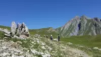
What a wonderful discovery, these high-altitude lakes whose names are associated with a color or shape! And what a setting! Between pastures and a very mineral atmosphere, you can also taste goat cheeses near the fort!
Description
After the long 5 km carriage track, you're at the start of the hike, at Fort de la Platte! Also known as the "Fort des 2000" because of its altitude, this Séré de Rivières-type structure keeps a watchful eye on the valley, aided by a herd of curious goats.
Like a guardian, it has preserved all the magic of the Forclaz valley, which you are invited to enter. After a beautiful ascent to the alpine pastures, where you'll see the last immaculate névés, chamois and ibex should be there under the aiguille de Terrassin, where they love to bask.
You'll soon arrive at the first glacial lake, "Esola", which means "starry lake". And it would be a shame to stop there without discovering the round "Riondet" lake, the "Cornu" lake, or the emerald-colored "Verdet" lake. The atmosphere becomes more mineral before reaching the largest of them all: the mysterious black lake.
After a pleasant picnic, it's time to think about heading back down. Along the way, you'll enjoy the fragrant, multicolored mountain flora. Back at the fort, drinks and goat's cheese tasting for all!
Opening period
From 01/06 to 31/10.
Subject to favorable snow and weather conditions.
Services
- Services
- Pets welcome
Situation
From the Bourg St Maurice tourist office, Place de La Gare, head towards Le Cormet de Roselend / Les Chapieux. 3 km from Bourg, pass through a small village called Le Chatelard; as you leave it, turn left towards Le Fort de La Platte. Pass through several small villages: Le Villaret sur la Cote, Les Echines dessous, Les Echines dessus and continue along the road towards Pont du Moulin, then Fort du Truc.
Capacity and customer types
- Target audiences
- Walkers/hikers
- Level bue - Medium
- Pets allowed
- Yes
Environment
- Mountain location
Directions
- Distance : 9.8km
- Durée journalière : 270min
- Dénivelé + : 640m
- Dénivelé - : 640m
- Altitude max : 2532m
Practical information
Contact and information
Location